Joint project - Research
The collaborative project is divided into five modules, including the coordination. All modules are linked with each other in order to integratively analyse the briefly described research questions and goals. For this purpose interdisciplinary and transdisciplinary methods shall be applied. Methods and models from the natural sciences will be used as well as those from the social sciences.
- development of scenarios and land management strategies in dialogue with stakeholders
- integrated climate and bio-physical as well as socio-economic modelling, trans-sectorally, comprehensively and regionally differentiated,
- evaluation of climatic, ecological and socioeconomic impacts of land use options
- exemplary check of the social sustainability and feasibility of options of action in example regions
According to the inter- and transdisciplinary research approach, various results are to be expected from CC-LandStraD
- trans-sector land use scenarios for Germany created in an iterative process with stakeholders
- further developed modelling of the interaction between land use and climate change
- model supported impact analyses of land use strategies under changing global framework conditions (for example climate changes, market influences)
- presentation of existing goal conflicts between climate-optimized land use strategies and other societal demands
- quantification of societal preferences for land use strategies
- inclusion of climate protection aspects in the decision-making and change processes.
Model descriptions
More detailed information on the models used can be found below.
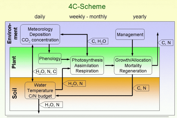
The model 4C (‘FORESEE’ - Forest Ecosystems in a Changing Environment) has been developed to describe long-term forest behaviour under changing environmental conditions (Lasch et al., 2005). It describes processes on the tree and stand level basing on findings from eco-physiological experiments, long term observations and physiological modelling. The model includes descriptions of tree species composition, forest structure, total ecosystem carbon content as well as leaf area index. The model shares a number of features with gap models, which have often been used for the simulation of long-term forest development. Establishment, growth and mortality of tree cohorts are explicitly modelled on a patch on which horizontal homogeneity is assumed. The results are used to analyse forest productivity (11 European tree species); the carbon, water, and nitrogen budgets of forests including soil; to derive reduced models for application in information systems; to analyse adaption of forestry to climate change by management, and to estimate the bioenergy potential from short rotation coppice.
Currently the model is parameterised for the five most abundant tree species of Central Europe (beech, Fagus sylvatica L.; Norway spruce, Picea abies L. Karst., Scots pine, Pinus sylvestris L., oaks, Quercus robur L., and Quercus petraea Liebl., and birch, Betula pendula Roth), as well as aspen (Populus tremula (L.), P. tremuloides (Michx.)), Douglas-fir (Pseudotsuga menziesii), Aleppo pine (Pinus halepensis Mill.), and Ponderosa pine (Pinus ponderosa Dougl.).
Specifics:
4C allows forests from the Mediterranean to the Boreal regions to be simulated because of the large set of parameterised tree species and processes. 4C was successfully compared with other models in the framework of different projects.
Input-Data:
Climate driving variables on a daily resolution (e.g., temperature, relative humidity, precipitation, radiation), annual data of atmospheric CO2 concentration and nitrogen deposition (optional), soil description (physical and chemical parameters), stand description
Results:
Simulation of forest stand growth (diameter, height, volume), leaf area index, ecosystem carbon, water and nitrogen balance in various time steps (fluxes and pools)
Software:
FORTRAN90
Homepage:
http://www.pik-potsdam.de/~lasch/4c.htm
References:
Lasch, P.; Badeck, F.W.; Suckow, F.; Lindner, M.; Mohr, P. (2005)
Model-based analysis of management alternatives at stand and regional level in Brandenburg (Germany).
For. Ecol. Manage. 207(1-2): 59-74, englisch
The Land Use Scanner integrates projections of land use claims from external sectoral models to allocate changes of land use and land cover on a grid. Driving forces for spatial allocation of land use change are formulated in terms of local suitability based on a large digital and geographic data base. It was developed as operational tool for the integrated development of future land use patterns.
Type:
Operational, GIS-based and spatially explicit mathematical simulation model based on discrete choice theory
Specific use:
Policy-related research projects to develop scenarios of future land use change
Main partners:
Object Vision BV, Amsterdam; Vrije Universiteit Amsterdam, Netherlands Environmental Assessment Agency
Specifics:
- Grid based simulation with 100m spatial resolution in the Netherlands and 250m in the Elbe River Basin
- Integration of different land use types from different economic sectors (urban, forest, agriculture)
- Implementation of spatial planning data since actual land use is not merely the effect of market forces
Data base:
Includes, for example, current land cover, topography, crop yield potential, distances to infrastructure and land uses, spatial planning maps, regional claims from external sectoral models
Results:
Maps of potential future land use and land cover pattern
Resolution:
Temporal simulation step: one time step for the target year / Spatial resolution: 250m (changes to coarser spatial resolutions are possible within the model)
Endogenous variables:
Refer to data base
Exogenous variables:
Regional claims from external sectoral models
Software:
Data and Model Server software running under Windows platforms
References:
Hilferink, M.; Rietveld, P. (1999)
Land Use Scanner: An integrated GIS based model for long term projections of land use in urban and rural areas.
In: Journal of Geographical Systems, 1(2): 155-177, englisch
Koomen, E.; Stillwell, J.; Bakema, A.; Scholten, H.J. (Eds.) (2007)
Modelling Land-Use Change. Progress and Applications.
Series: GeoJournal Library, Vol. 90, Springer, englisch
RAUMIS is a regionalised agricultural and environmental information system and simulates the impacts of agricultural and environmental policies on the regional agricultural land use, production, income and the environment. Adjustments are modelled in a comparative static setting.
Type:
Mathematical programming model with a non-linear objective function
Main fields of application:
Analyses of policy impacts of the CAP, analyses of measures to implement the EU water framework directive, the Kyoto-Protocol or renewable energy, adjustments of global (climate) change, input-output analyses for the environmental accounts
Main partners:
Federal Ministry for Food, Agriculture and Consumer Protection, University of Bonn, Potsdam Institute for Climate Impact Research (Potsdam), Research Centre Jülich, Helmholtz Centre for Environmental Research UFZ (Leipzig)
Specifics:
- Consistent to national agriculture accounts, encompasses total agricultural production, total input use, and agricultural income
- Calculation of agri-environmental indicators (e.g., nutrient balances, green house gas emissions) consistent to report obligations
- Coupling with different model types, for example, general computable equilibrium models and natural science models
Data base:
National accounts of agriculture, farm structure survey, calculation data, calibrated base years 1979, 1983, 1987, 1991, 1995 und 1999 (2003 and 2007 in preparation)
Countries and regions:
Germany, 326 model regions (NUTS III / counties)
Sectors and Differentiation of production:
Primary production of the agricultural sector / 31 crop and 16 livestock activities
Policy instruments:
Production quotas, direct payments, decoupling, set-aside, stocking rate limits, minimum land use requirements, agro-environmental requirements
Trade:
Interregional transports (e.g., manure), quotas, set-aside obligations, young animals
Endogenous variables:
Supply quantities and income on regional and sector scale. Trade (quotas, manure, set-aside) between regions
Exogenous variables:
Product prices, policy variables (e.g., area payments, quotas, production obligations), projection of technical coefficients
Software:
FORTRAN (planned: change to GAMS)
This model is part of the Thünen model network. For more information on the model network please click here.
The Statistical Regional Model (STAR) was developed to so augment the climate simulation results of global models so that their inexactness with regard to regional statements can be reduced to a minimum. Here generalized trend information from global climate model results are used as the departure point for a regional augmentation. These statistics and their changes are coupled with available observation data into specially developed similarity relationships.
Type:
Mathematical simulation model
Typical Application:
Climate scenarios consisting of n realisations for a selected future time period.
Special Features:
- Random spatial (points) and time (hour) resolution depending on the available observation data
- Any number of scenario realizations
- Possibility of freely chosen pre-settings of climate changes, for example, to simulate extreme situations
Data base:
Generalized trends for a selected study region derived from the course of a Global Circulation Model (GCM) scenario, time rows of observation data on a daily value basis.
Countries and regions:
Spatial resolution: stations, capable of being interpolated on any grid
Time resolution: >=1 day
Endogenous variables:
Regional temperature trends derived from the GCM, observed meteorological statistics at each station.
Exogenous variables:
Predicted meteorological statistics for the region considered
Software:
Implemented on UNIX and Linux, transferable to Windows
STAR was developed by the Potsdam Institute for Climate Impact Research (PIK). Further information can be found under www.cec-potsdam.de/Produkte/Klima/STAR/star.html (German)
References:
Werner, P.C.; Gerstengarbe, F.-W. (1997)
A proposal for the development of climate scenarios.
Climate Research, 8, 3, 171-182, englisch
Werner, P.C.; Gerstengarbe, F.-W. (1997)
Der Aufbau von regionalen Klimaszenarien, dargestellt am Beispiel der Region Brandenburg.
Ann. Meteor., 34, 75-76, deutsch
Wessolek, G.; Gerstengarbe, F.-W.; Werner, P.C. (1998)
A new climate scenario model and its application for regional water balance studies.
In: Proceedings of the 2nd Int. Conf. on Climate and Water, Espoo, Finland, Vol. 1, 160-171, englisch
Model description SWIM
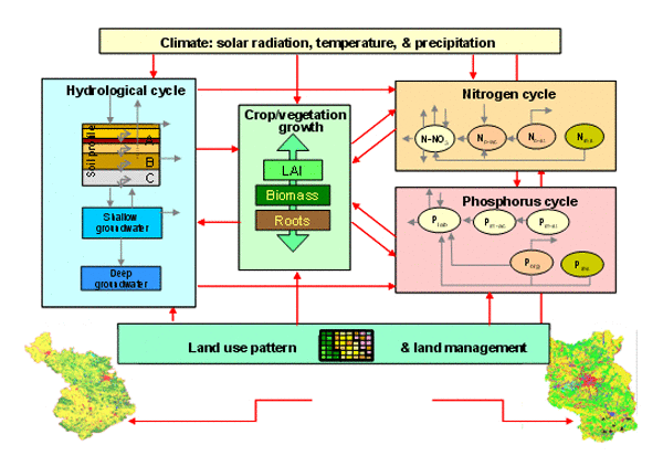
SWIM - Soil and Water Integrated Model - integrates the relevant eco-hydrological processes including water flow, nutrient transport and turn-over, vegetation (crop) growth and land use and water management needed to investigate climate and land use change impacts on hydrological systems and on vegetation at the regional scale. It was developed to investigate impacts of land use and climate change on hydrology and vegetation (crop yields).
Resolution:
Temporal resolution: daily
Spatial resolution: hydrotopes, whereby each unique combination of the underlying geographical maps (soils, land use, etc.) forms one hydrotope class. Lateral flows are aggregated at the subbasin scale.
Input-Data:
Topography, land use, soil distribution and soil parameters, surface waters and river network, data from climatic and precipitation stations, water and land use management data, measured discharge data and measured values of nutrient concentrations (for calibration and validation).
Results:
Vertical and lateral water flows, plant biomass and crop yields, nitrogen- and phosphorus concentrations, sediment transport at daily, monthly or annual time steps and as GIS layers.
Software:
Fortran
SWIM was developed at the Potsdam Institute for Climate Impact Research (PIK). Further information is available at http://www.pik-potsdam.de/ ~valen/swim_manual
References:
Hattermann F.F. (2005)
Integrated modeling of global change in the German Elbe river basin.
Dissertation, englisch
Krysanova V. et al. (2000)
PIK Report Nr.69 “SWIM (Soil and Water Integrated Model), User Manual”
239 p., englisch
Test Regions in CC-LandStraD
CC-LandStraD develops societal based land use strategies for Germany. This includes strategies for climate mitigation and adaptation. Therefore the researchers analyse the interactions between different land use forms and the climate change area-wide for Germany. In Germany, land use is primarily agriculture (52%), forestry (30%) and the sector settlement and traffic (14%). The following map provides an overview about the current regional land use in Germany.
Land use in Germany (2006)
(Map; pdf; not barrier free; 909 KB)
Based on the ascertained interdependencies between land use and climate change the project team will deduce options and measures, which have an impact on both aspects of climate change. The scopes of implementation of these options and measures will be analysed in two selected case study regions by the subproject “Regional Participation Processes”. Case study regions are the Altmark and regions in the Cologne Bay. Further information regarding the case study regions you find here.