Water and matter household
Title of the subproject:
Impacts of land use change on the water, carbon and nitrogen balance of the landscape
Introduction:
This subproject focuses on matter and nutrient balances under climate and land use change and allows for the evaluation of the contribution of land use change to the climate adaptation and mitigation goals of Germany. The subproject supports answering research questions related inter alia to the adaptation of land management and the trade-offs between carbon optimised land management and societal needs regarding biomass production from agriculture and forestry.
Institution:
Potsdam-Institute Climate Impact Research (PIK)
Aims
The subproject will estimate quantitatively changes in the nation-wide water, carbon and nitrogen household of Germany’s river basins due to land use and climate change. The overall aim is the preparation of quantitative predictions of impacts of individual land use strategies under various climate change scenarios to subsequently be able to compare and rate them among each other.
Research approach and methods
Simulation set-up
The investigations will be carried out for current and possible alternative land use schemes combined with the current climate and scenarios for the anticipated climate change. The assessment will be based on a modelling system consisting of the statistical climate model STAR, the eco-hydrological model SWIM and the forest model 4C (http://www.pik-potsdam.de/~lasch/4c.htm). The subproject contributes mainly to the Module M "Integrated Modelling"of CC-LandStraD.
The modelling system will follow the pool and flow dynamics of idealised soil-plant-atmosphere systems of the major landscapes in a daily mode for a transient climate period from 1960 up to 2060. The models are validated using monitoring data, satellite scenes, temperature measurements and outlet gauge data of river basins. The simulation results for water, carbon and nitrogen characteristics of agriculture and forestry can subsequently be aggregated to higher administrative and landscape units and to various time slices. The conceptual coupling of the SWIM-4C simulations with GHG emission modules and the preparation of modelling results for focus regions, GLUES and the integrated assessment are intended.
Additionally the subproject will deliver regionalised climate data and projections of climate scenarios on the basis of the IPCC-Assessment Report 4 using the statistical climate model STAR 2.0. In case of specific stakeholder requirements climate change scenarios can be adjusted according to their needs and input from the GLUES project.
Simulation set-up: forest
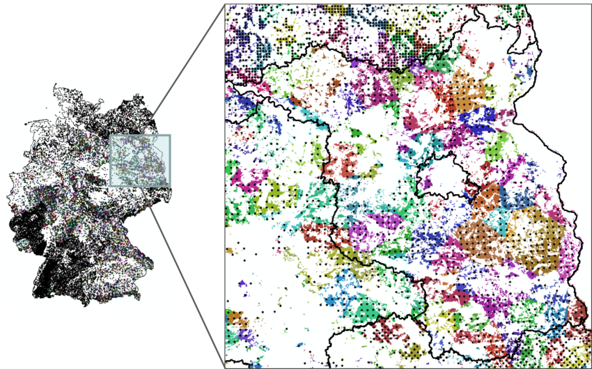
The simulations with 4C aim at the analysis of land use and climate change scenario impacts on the carbon, water and nutrient budgets of forests in Germany. This approach requires a spatial representation of the whole forest area of Germany. The model 4C simulates single forest stands but a complete description of all forest stands in Germany does not exist. For this reason we use a representative sample which is given by the National Forest Inventory (Bundeswaldinventur, BWI). The BWI reports forest specific parameters of sample plots on a regular grid (for more details see https://www.bundeswaldinventur.de/en/).
The data given by the BWI2 (2002) were prepared for the application with 4C. For this purpose some simplifications of the forest stand structure were assumed which ensure that the aggregation of forest data at district, federal state and country level are correct with respect to the BWI2. We use the parameters "age" and "species type" of the sample plots to generate representative forest stands. In a second step we assign these stands state, species type and age class specific values of 'height', 'diameter at breast height' and 'basal area' and initialise these stands with 4C. Each of these stands was distributed evenly by the respective forest area (determined by satellite data: www.corine.dfd.dlr.de) (see Figure). We only took into account the forest species Norway spruce, Scots pine, Douglas fir, beech and oak (without distinguishing between sessile and common oak).
Results
Interim results agricultural land use
SWIM was set-up with a homogeneous German-wide input data set to quantitatively estimate the impact of various land use change in combination with climate change scenarios. Input data encompass the German soil map "BÜK 1000", the land use map CORINE, a subbasin map, a digital elevation model and climate data. Details about the input data can be found in Huang et al. (2010).
In a first step historic simulations (1991-2010) were run to test the applicability of the model to reasonably simulate impacts of land use scenarios on water and matter budgets. In the first instance the focus lay on the simulation of crop yields since they are key factors determining water, carbon and nitrogen flows in the landscape and in river runoff. Simulated yields of winter wheat and silage maize were evaluated at county level against statistical yield information (see Figure).
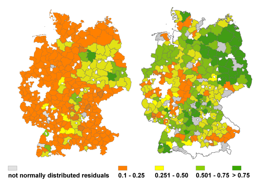
Overall results show that the model can explain on average 66 % of the interannual yield variability of silage maize for the period 1991 - 2010 at federal county level. Values range from 37 % in Schleswig-Holstein up to 92 % for Brandenburg. This reveals a clear trend that simulation results are on average better for the drier east part of Germany than for the wetter regions of the western part of Germany. Results for winter wheat show lower performance which can be explained by the higher – and not met – demand for input information of crop management and model process resolution for winter grown crops. However, our results fall well within the range of internationally published results on spatial yield simulations.
Reference:
Huang, S., Krysanova, V., Österle, H., Hattermann, F.F., 2010. Simulation of spatiotemporal dynamics of water fluxes in Germany under climate change. Hydrological Processes 24, 3289-3306
Interim results forestal land use
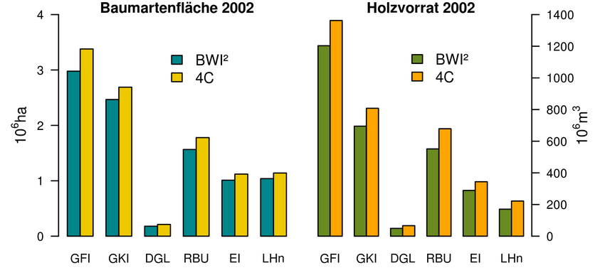
In a first step we checked if the described method is sufficiently precise to generate a representation of the aggregated BWI results. The initialisation of all forest stands by 4C overestimates slightly the timber stock and the area share of the tree species. This is caused mainly by the fact that other tree species than mentioned above could not be considered. Overall, the proportions among tree species groups are described very well for the whole forest area (see Figure) as well as for the federal states.
Results forest land use
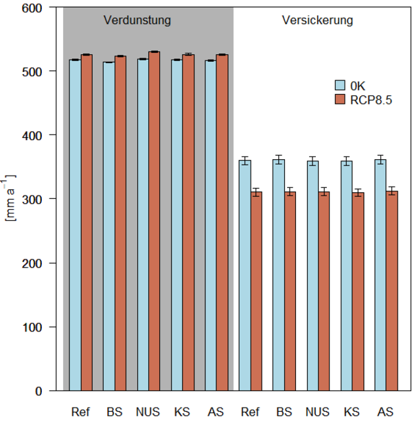
Analyses of the carbon and water budgets of Germany’s forests were carried out using the data base of the National Forest Inventory (BWI2), two climate change scenarios (0K – no temperature change, and RCP8.5), and five land use/ management strategies for the time period 2011 - 2050. In addition to the business as usual strategy four alternative management strategies were developed which differ in forest species composition, thinning intensity, final harvesting, and proportion of unused forest area. The assessment of the results shows that management clearly influences the carbon budget whereas the impacts of the climate scenarios differ only slightly. The recent management, business as usual (BAU), but mainly the bioenergy by biomass (BE) and the climate adaptation (CA) strategies lead to losses of carbon sequestration in above and below ground biomass. Under the climate mitigation (CM) and the nature and environmental protection (NEP) strategy the carbon sequestration in biomass increases (see Figure 1).
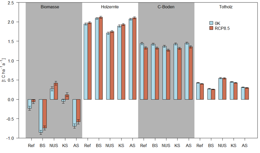
The amount of harvested timber depends strongly from the management strategy and is clearly higher for the bioenergy by biomass and the climate adaptation strategy than for the other strategies. The highest carbon sequestration in deadwood is realised by the nature and environmental protection strategy and the lowest is found for the bioenergy by biomass strategy. We stated that soil carbon sequestration is barely influenced by management. But, the climate scenario RCP8.5, describing a considerably increase of temperature, leads to a lower carbon accumulation in soils than the 0K scenario.
The annual mean actual evapotranspiration and percolation is less sensitive regarding the management strategy. The evapotranspiration increases slightly under the RCP8.5 scenario in comparison to the 0K scenario. The percolation is clearly lower under the RCP8.5 scenario independently from the management strategy (see Figure 2).