Participation on regional level
Project description
Title of the subproject:
Participative approaches of impact assessment
Introduction:
Recent experience has shown that insufficient integration of regional and local stakeholders poses a considerable threat to the successful implementation of sustainable land use strategies. Therefore, subproject 6 engages in a participatory and transdisciplinary multi-stakeholder dialogue. Stakeholder integration shall allow for capturing potential challenges for the implementation of sustainable land management strategies and shall ensure the integration of stakeholder perspectives already during strategy development.
Institution:
Leibniz-Center for Agricultural Landscape Research (ZALF) e. V.
Aims
The objective of subproject "Participation on regional level" is to analyse the regional conditions and options for sustainable land use in two case study regions in Germany with the involvement of relevant regional stakeholders. In this regard it will be elaborated to
- what extent existing societal interventions in the region determine land use,
- which conflicts do result, and
- how local stakeholders perceive these developments and interpret them in view of the future.
Research approach and methods
Subproject "Participation on regional level" has two modules.
- Module 1:
characterise the situation in regard to land use and land use changes in the case study regions.
- Module 2:
involvement of actors perspectives, e.g., as iterative feedback on the results of the collaborative modelling network (scientific expert knowledge).
In module 1, the socio-economic structures in the focus region will be described and relevant local stakeholders will be identified. The second step will survey individual perceptions of problems and their appraisal of relevant stakeholder. In a third step, management options under climate change will be discussed in focus workshops. This will underpin the regional scenarios and strategies for a sustainable land use management.
The objective of module 2 is an iterative feedback on the results of the collaborative modelling network (scientific expert knowledge). In the end, land use options that go along with the existing land use systems will be conducted.
The first task is a synopsis of specific local guiding principles and management guidelines and integrated land use modelling. Then further modelling results will be the core of deliberative stakeholder dialogue. Scenarios, land management strategies and land use option will be systematically developed and evaluated.
The important part of this work package is the identification of local conflicts stemming from implementing sustainable land management strategies. A criteria and indicator system will help to evaluate potential conflicts and land use options counteracting global changes. The scenario discussion results will take the social feasibility into account. The transdisciplinary collaboration will yield in the end socially accepted, sustainable and efficient land use options and a clear stakeholder vote about the bottlenecks and impacts.
The methodological approach in this subproject covers a statistical analysis, the review of secondary documents and the relevant literature. In addition, semi-structured interviews with stakeholder focus groups and participatory interdisciplinary workshops will be held.
Results and documentation
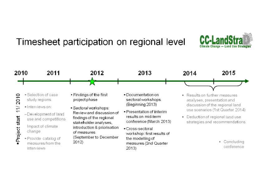
(Time sheet to download as pdf; not barrier free; 608 KB)
In the sub-project "Participation on the regional level", the two case study regions have been characterised in a stakeholder analysis. First interim results and the documentation on the participation process to date have already been compiled (see column right).
The next activities will be sectoral and cross-sectoral workshops to be held in the case study regions. Details on the up-coming activities can be found on the time sheet.
Documentation
Workshop documentation: "Interdependencies between land use and climate change" (June 2015)
Download as pdf (not barrier free; 170 KB; German)
Stakeholder analyses case study regions (summary)
Download as pdf (not barrier free; 55 KB)
Case study regions
As case study regions were chosen the Altmark and regions in the Cologne-Lowland. A brief characteristic of both regions follows:
Case study region Altmark
Administratively, the Altmark consists of the Altmark County Salzwedel and Stendal County. Spatially, the Altmark is bounded by on the Luneburg Heath and the Wendland to the west and to the North by the region Prignitz. To the east the border is the river Elbe basin and the Jerichower Land, and in the South the Altmark is bordered by the Magdeburger Plain. In terms of greater structural area, the Altmark can be categorized as North German Plain and comprises 471,570 ha.
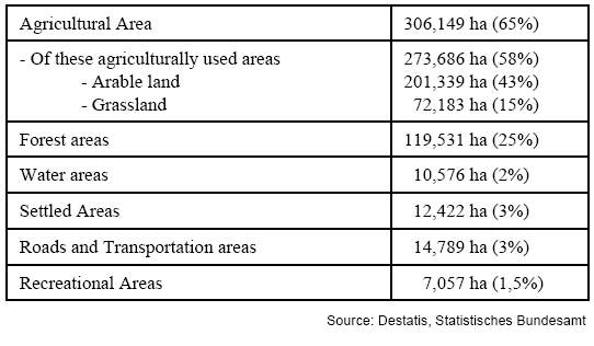
Land use is primarily agriculture (58 %) and forestry (25 %). About 12 % of the area is limited by strongly protected land use. Here in particular is the nature park Drömling (278 km²) in the south of the Altmark. Water areas are in particular the Elbe River basin. The detailed area use in the Altmark can be drawn from the following table:
The county’s transportation infrastructure includes the ICE High Speed Transit (Stendal). The construction of an Autobahn from Magdeburg to Schwerin is planned (transportation area 1 %).
The Altmark climate reveals and average annual temperature of about 9°C. and a rather average precipitation level of under 600 mm per year.
About 214,000 people live in the Altmark (2009). That is a population density of 45 inhabitants per km². Between 1995 and 2010 the population in the Altmark reduced by 16.2 %. By 2025 a reduction of 19.9 % is expected.
The occupational structure is marked by the services sector (44%) and manufacturing (30 %). Trade, tourism and transportation comprise 21 %, and 5 % are employed in agriculture and forestry. Thus the portion of persons working in agriculture and forestry is higher than the national portion (2.2 %) (2009). Tourism is of supra-regional significance particularly in the areas of water, bicycle and horseback riding tourism. Both counties show a commuter deficit. Unemployment in the Altmark is 14.1 % (2009).
Case study region Rhein-Sieg County
Administratively, Rhein-Sieg County belongs to the Cologne Region and to the Bonn/Rhein planning district. Spatially, the region is at the cross-section between the Lower Rhine Bay and the Rhine Slate Mountains and is marked by low mountains, hills and plains. To the North the region borders on Cologne Bay, to the South on Lower Westerwald and the central Rhine area. From West to East, the county ranges from the slopes of the Eifel into the Bergische Land. The county comprises 115,330 ha.
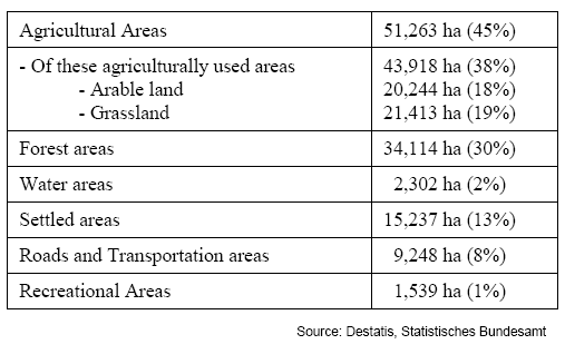
Agriculture and Forestry predominate as forms of land use. About 38 % of the land is used for agriculture and about 30 % for forestry. The portion of strictly protected areas (natural protection areas and natural parks) was 13 % in 2007. Among these are the Bergisches Land Natural Park, Rheinland and the Siebengebirge Nature Park. Due to the many dams in the region, 11,000 ha are water protection areas. Detailed information on land area use in Rhein-Sieg County can be drawn from the following table:
The county’s transportation infrastructure includes the ICE High Speed Transit (Cologne), easy access to the Cologne/Bonn airport and to three Autobahns (the 1, 3, and 4).
Climatically, Rheinisch-Bergisch County features and average annual temperature of 9°C and an average precipitation level of 750-800 mm per year.
About 277,000 inhabitants live in Rheinisch-Bergisch County. This represents a population density of 634 persons per km². Forecasts indicate that the population will increase slightly (1.5 %) from 2007 to 2020.
The employment structure is marked by the service sector (49 %) About 26 % are employed in trades, the hotel and restaurant industry and the transportation industry and 23 % are employed in manufacturing. A total of 2 % work in agriculture. In tourism, the county is well-known for its recreational offerings for the local urban centers. In 2009, Rheinisch-Bergisch County had a commuter surplus. At 6.6 %, unemployment was under the North Rhine-Westfalia average of 8.1 %.
Case study region Rheinisch-Bergisch County
Administratively, Rheinisch-Bergisch County belongs to the Cologne Region and to the Cologne planning district. Spatially, the region lies between the Rheinland and Bergisch Land and is part of the Rhine Slate Mountains. The county comprises 43,750 ha.
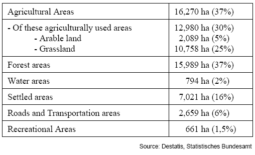
Land use is most strongly marked by forestry (37 %). Agriculture is pursued on 30 % of the areas. Extensive farming dominates here. The portion of strictly protected areas in 2007 was 11 % of the area. Included here, is, for example, the Bergisch Land Natural Park. Due to a large number of dams in the region, 16,700 ha are water protection areas. Detailed information on land area use in Rheinisch-Bergisch County can be drawn from the following table:
The county’s transportation infrastructure includes the ICE High Speed Transit (Bonn/Siegburg), easy access to the Cologne/Bonn airport and to three Autobahns (the 3, 59, and 61).
Climatically, Rhein-Sieg county features and average annual temperature of 9°C and an average precipitation level of 750-800 mm per year.
About 568,000 inhabitants live in Rhein-Sieg county. This represents a population density of 519 persons per km². From 1991 to 2006 the population grew by 17 %. Forecasts indicate that the population will continue to increase until 2025.
The employment structure is marked by the service sector (50 %), as well as trades, the hotel and restaurant industry and the transportation industry (26 %) (2008). About 22 % are employed in manufacturing and 2 % in agriculture and forestry. Tourism is of particular importance in the Rhine Valley. The county has a commuter deficit. At 5.5 % in November 2010, unemployment was under the North Rhine-Westfalia average of 8.1 %.