Land use scenarios
Title of the subproject:
Settlement and land-use scenario 2030 for a climate-optimised settlements development (Land-use Scenario 2030; BBSR)
Introduction:
The expansion of settlements and the settlement structure have a considerable impact on climate change. A decentralised and compact settlement structure, which is nevertheless green and geared to expanding the public transport infrastructure, is said to have an important share in reducing CO2 emissions especially from transport and domestic fuel. However, compact and qualitatively concentrated settlement structures also bring about resilience and, thus, helping areas to proactively adapt to the inevitable impacts of climate change.
But the expansion of settlements and the related dispersion and fragmentation of settlements also have a direct impact on open areas especially used as agricultural land. These trends indirectly reduce options for a climate-proof land-use management. Its impact on climate protection and adaptation to climate change is again impaired by urban restructuring activities including demolition, land recycling and unsealing activities as well as by the transformation of urban-like landscapes such as conversion areas in the open land, open-cast mining landscapes or renewable energy production areas.
Poster to download (PDF; not barrier free; 3,6 MB; German)
Institution:
Federal Institute for Research on Building, Urban Affairs and Spatial Development (BBSR)
Aims
The subproject "Land-Use Scenario 2030" is therefore oriented towards the built-up parts of landscapes, especially settlement areas, and focuses on scenarios of their future development. The latter are to calculate the amount of future settlement and transport areas, thus also defining the amount of remaining open areas, which again provides the basis for other CC-LandStraD subprojects. Furthermore the scenarios shall help to identify strategies for a CO2-reducing settlements development.
The objective of the subproject is to develop a land-use scenario 2030. A trend forecast (business as usual) is used to identify the land use expected as well as scenarios for 2030. The subproject "Land-Use Scenario 2030" thus mainly serves to forecast and regionalise the development of settlement and transport areas in Germany. The results will be examined in terms of their climatic effect and combined with the results of the other subprojects.
Research approach and methods
First of all, a trend forecast will be produced to develop the land-use scenarios 2030. A trend forecast is a likely future development that results from historic development, adopted policies and expert judgment. Other development scenarios, which are based on different economic, political and demographic estimates, are to illustrate the variety of possible development trends of land use in 2030.
The expansion of settlement and transport areas in Germany nearly exclusively goes along with the rezoning of former agricultural areas. The calculations are to demonstrate how much (agricultural) land tends to be required by additional settlement and transport areas according to each scenario. The climate effect of the scenarios will then be evaluated. It will also be necessary to check the possibility of bringing the estimated land use into line with the climate-optimised land use.
Scenarios:
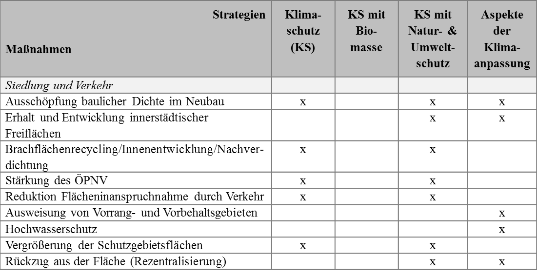
The following table gives an overview about the climate change adaptation and mitigation measures for settlement and transport areas. These measures are assigned to different scenario strategies (state of discussion June 2013)
Modelling framework – settlement and transport areas
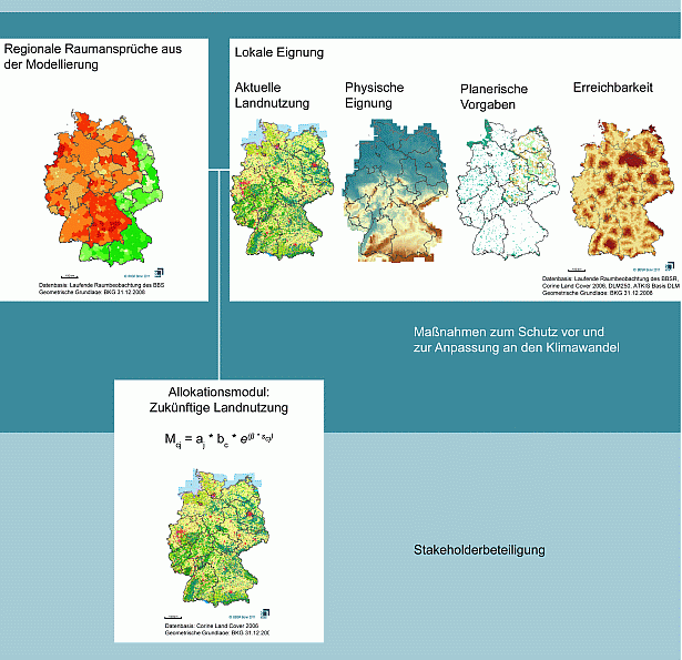
In a first step, projections of regional claims for every single land use type are developed (e.g. settlement and transport area, agriculture, forest). The claims for urban land use types are estimated by the model PANTA RHEI REGIO that was developed by the GWS Osnabrück. The model estimates the settlement and transport area, differentiated by urban land use type (residential, industry / commercial, transport area, leisure facilities, urban green areas), based on the historic trends of settlement structure, demographic and economic development on Nuts3 level for the year 2030. The demographic development is provided by the population and household forecast of the BBSR. In a second step, these results serve as input information for the land use change model Land Use Scanner. It is a GIS based simulation model where qualitatively formulated scenarios are underlaid quantitatively and are explicitly simulated spatially. On the basis of spatial land use data, the spatial planning and further location factors such as relief or accessibility the local suitability of individual land uses will be assessed. Regional spatial demands and local suitability are ultimately integrated in the Land Use Scanner. The model simulates the explicit land use changes spatially, based on the microeconomic theory of land rents. With the help of further land use patterns, the effectiveness of single simulated adaptation methods can ultimately be assessed.
Results
Demand for land
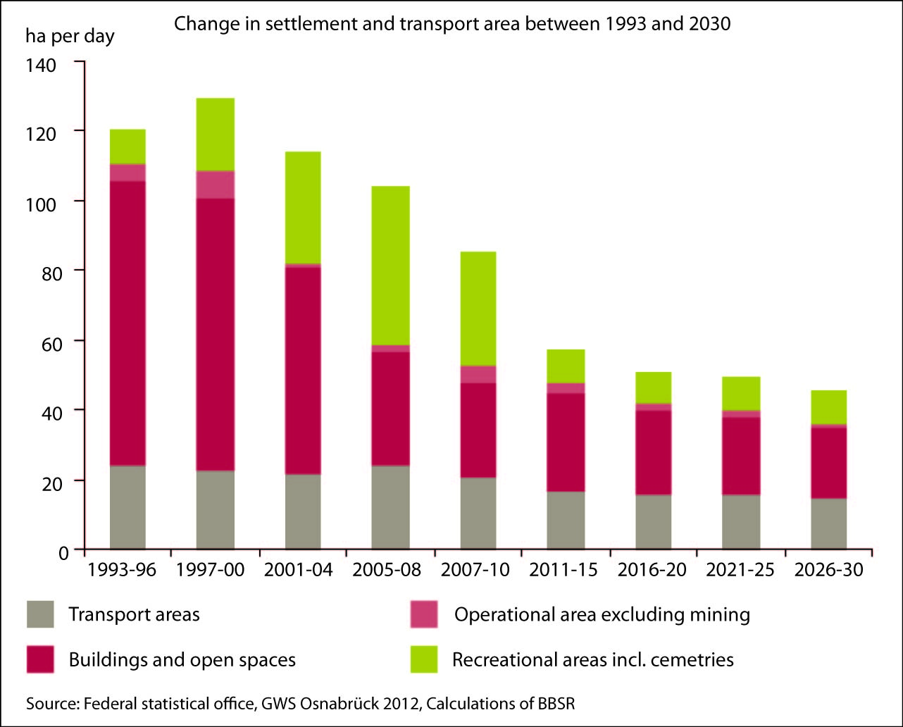
The demand for settlement and transport area was estimated for the year 2030 in the trend forecast for all urban land use types. The results show that the demand for settlement and transport area declines from currently 87 ha (2007 to 2010) per day to 45 ha until 2030. The proportion of settlement and transport area to the total area of Germany thus increases from 13.3 % in 2010 to 14.5 % in 2030. While the demand for buildings and open spaces as well as recreational areas declines, the demand for transport areas remains constant. The spatial distribution of the results shows an increasing importance of large West German cities. But the demand for settlement and transport area remains the highest in West German suburban areas. The reason for this development is the underlying migration pattern. Immigrants prefer economically strong urban centres. More detailed results are published in BBSR Analysen KOMPAKT 09/2012 (in German only).
Database for the land use simulation
1. Current land use
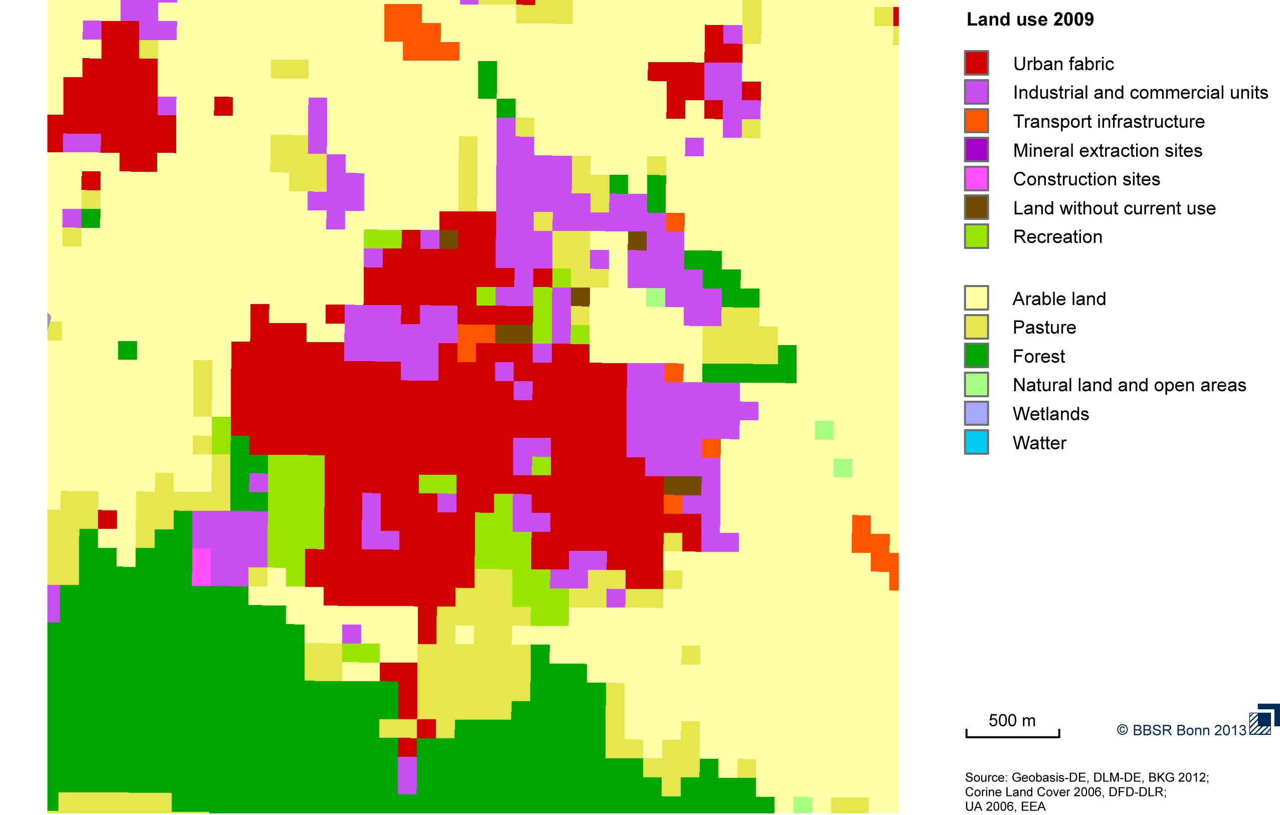
The simulation of land use changes requires information on the current land use. Recently, there are several data bases available which differ in their temporal, spatial and thematic resolution. Therefore, the datasets had to be tested for their suitability to be used for land use simulation. The result shows that most types of land use can be described sufficiently whereas mapping of linear elements like roads or railways remains difficult, due to the applied minimum mapping units. The following figure gives a comparative overview of the tested land use datasets and the share of different land use types of the study area.
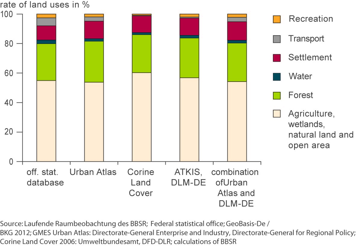
Within CC-LandStraD a combined dataset of DLM-DE (BKG) and Urban Atlas (EEA) is used. The figure gives an impression of the spatial and thematic resolution of the land use data.
An overview of all analysed land use datasets as well as the results of a map comparison are published in BBSR Analysen KOMPAKT 02/2013 (in German only) and in a short version in Window on GMES (in English).
2. Local suitability
The local suitability is influenced by the current land use pattern as well as additional location factors. There are for example bio-geophysical factors such as slope and height of the terrain or soil quality for agricultural land use. Additionally, requirements from spatial planning and nature protection are implemented: mainly negative and positive planning provisions have a controlling effect on the development of settlements in the model. In addition to planning requirements and supply-side factors, land use decisions depend on economic factors like distances and accessibility of cities and markets which are also included in the modeling. Here the data access model of the BBSR is used.
3. Simulation results for the reference scenario
First, the change in land use was projected up to the year 2030 using the Land Use Scanner simulation model.